Mastodon Climate Citizen --> Mastodon
Showing posts with label precipitation. Show all posts

Thursday, April 30, 2015

Seventy Five percent of heatwaves now attributed to climate change


The original of this article was published at nofibs.com.au

The latest study of extreme weather events has concluded that 3 out of 4 heatwaves and extreme heat events and nearly one in five heavy rainfall events, on a global scale, can be attributed to human contributions to global warming through greenhouse gas emissions. As temperatures continue to rise, the percentage is set to increase even further.

The researchers looked at 'moderate' extremes, which they defined as events expected to occur on 1 in every 1,000 days under present conditions. It involved examining data on extreme weather events around the globe in a dataset going back more than 100 years, and using two dozen climate models.

There has been a growing ability to attribute some single extreme weather events via Fractional Attribution of Risk (FAR) to anthropogenic climate change. Some of the specific individual extreme heatwave and precipitation events that have directly been attributed include the flood risk in England and Wales in autumn 2000 (Pall et al 2013), the European heatwave of 2003 (Stott et al 2004), the 2010 Russian heat wave (Otto et al 2012), and Australia’s record summer temperatures of 2013 (Lewis and Karoly 2013).

This study, rather than looking at individual events, examined the change in extreme weather events on a global scale for the statistical attribution to climate change.

Friday, January 9, 2015

UK: Evenly spread heat for warmest year on record in 2014


One of the longest continuous instrumental temperature records dating back to 1659, the Central England temperature record shows 2014 was the warmest year on record with a mean temperature of 10.93 °C, narrowly ahead of the previous record of 10.87 °C set in 2006.

Averaged across the UK it was also the warmest year on record with the annual mean temperature at 9.9 °C, which was 1.1 °C above the long-term (1981-2010) average and beat the previous record of 9.7 °C set in 2006. Eight of the top ten warmest years for the UK have occurred since 2002.

Thursday, October 10, 2013

Colorado extreme rainfall and flood event of 2013


Like many people around the world I watched and followed the astonishing rainfall and flood events in Colorado in September this year that resulted in at least 10 deaths, damaged some 18,000 homes, caused the evacuation of more than 10,000 people, washing away roads and bridges and isolating communities for a time. The rain and flood event is estimated to have caused $2 billion worth of damage.

The extent of the rainfall was unprecedented in meteorological records that stretch back a little more than 100 years. The extreme rainfall event has been described as a 1 in 1,000 year event. An Extremely rare combination of weather factors combining to produce the event.

Climate change however stacks the dice in several ways in increasing the probability of this event occurring in the future. A primary contribution is the increase in atmospheric capacity to carry water vapour which scientists have worked out to be 6 per cent to 7.5 per cent for each degree Celsius in average global warming. By the end of this century with average global surface temperatures projected to increase by 4 to 5 degrees with current business as usual scenarios, the atmospheric carrying capacity may be an extra 30 per cent, making extreme precipitation events like the Colorado event much more likely to occur.

Wednesday, June 26, 2013

Alberta Floods highlight a more active water cycle with climate change

An intense rainfall and storm event on June 20-21 has caused widespread flooding in the Canadian province of Alberta, encompassing much of the southern portion of the province including Canada's fourth largest city of Calgary. It is the worst flooding event in Alberta's recorded history, highlighting the more active hydrological cycle with climate change.

Over 120,000 people across the region were evacuated, 75,000 in Calgary (7% of the population), many now returning to flood damaged homes and businesses to start the clean up.

I am not going to say climate change caused the flooding. Clearly natural weather variability still plays a significant part in extreme weather events. But the reality is we have warmed the atmosphere and changed the base climate from which all extreme weather events are generated from. We are now living with weather in a more active hydrological cycle resulting in more frequent and intense storm events with a capacity to cause greater flooding.

Monday, April 1, 2013

Kevin Trenbeth on the 2011 Sea level Bump and Australia's wettest two year period


Did you know that during 2011 sea level rise went into reverse and lost 5mm from the global oceans? No? How about that since then, much to the chagrin of climate deniers, sea level rise has accelerated from 3.18mm per year - the rate from 1993 to 2010 - to increase to 10mm per year over the last two years. This acceleration more than makes up for the pothole. The primary cause of this sea level 'speed bump' was the back to back La Nina which moved a phenomenal amount of water from the global oceans to the land. The water has since been making it's way back into the world's oceans.

The question arises, does this explain the 10mm per year increase in sea level rise over the last 2 years? Is ocean thermal expansion or ice sheet melting perhaps contributing more? This may also be the start to an exponential sea level rise which NASA climatologist James Hansen has argued is a possibility. Rob Painting on Skeptical Science says that there is no evidence yet to suggest that ice loss from Greenland or Antarctica has added to the speed bump in any significant manner. We will have to wait and see what the impact of future El Nino or La Nina's will be on sea level rise, and keep watching the rate of mass loss from the ice sheets.

I came across this lecture by climatologist Kevin Trenbeth in which he talks about this sea level speed bump as a unique occurrence in recorded history. While previously there has been slight reductions in sea level rise corresponding to La Nina years, this event is a prominent change. Trenbeth discusses this extreme event near the end of his lecture on October 15, 2012. It is well worth watching the Youtube video if you have a spare 1 hour and 5 minutes. He provides an excellent introduction to climate change and extreme weather events and he is an animated speaker with clear and informative graphical and text slides.

Monday, January 28, 2013

Queensland 2013 bigwet floods, tornados and climate change

Ex-tropical cyclone Oswald has left a trail of damage and destruction from it's origins in the Gulf of Carpentaria to crossing Cape York and working it's way down the Queensland Coast. The storms brought destructive winds, tornados, rough seas, storm surge and torrential rain, followed by flooding. Quite a few rain records were broken for 24 and 48 hour periods in Rockhampton, Gladstone and Bundaberg with some rain gauges recording well over one metre of rain in 48 hours. Now flood level records are being broken for many river basins and towns like Bunderberg and Gympie.


Although the flood levels in Brisbane city may be lower than the devastating floods in 2011, largely due to better management of water storage in the Wivenhoe Dam, in many regional towns and areas these floods are much much worse and are at record levels.

While the Brisbane CBD may be spared flooding damage, many low lying suburbs around Brisbane will feel the force of the muddy dirty water swirling through their yards and houses. And regional towns are faring much worse in these floods than in 2011.

Thousands of people are being displaced, and hundreds are requiring rooftop emergency rescues from rapidly rising floodwaters especially around Bundaberg. Thousands will utilise emergency disaster assistance provided by State and Federal governments.

Asking whether climate change 'caused' these storms and floods is the wrong question. As climatologist Kevin Trenbeth outlines below, all weather events now have a component of climate change in them. It is now a part of our weather system contributing to all extreme weather events.

Saturday, January 26, 2013

Torrential rain, tornados on Queensland coast causing flash flooding and damage

Monday night: Significant flooding events are ocurring at Bundaberg, Gympie, Maryborough, Ipswich, Warwick and in the Lockyer Valley. Rockhampton is expecting significant flood from the Fitzroy river on the weekend. There have been four deaths so far confirmed and two people missing. Nearly 180,000 properties across SE Queensland are still without power Monday night reports Energex. Storm system now bringing torrential rain and flooding to NSW coast, expected to be over Sydney Tuesday dawn and the Illawarra during Tuesday morning before heading out to sea.

In Bundaberg the Burnett River is at 9.2 metres and rising fast, with flow speeds of about 40knots (70km/hr). It is expected to peak at a record level of 9.5 metres late on Tuesday. There was mandatory evacuations carried out today affecting about 5000 people, with over 1500 people from 1000 properties are in evacuation centres. 16 helicopters were brought in, including 4 Black Hawks from the Australian Defence Force to rescue people from house roofs after flood waters rose rapidly today. Patients from Bundaberg hospital are being evacuated to Brisbane.

Sunday 6pm: Rain Likely to continue overnight then subside as the system moves south into NSW. Substantial flooding is occurring in Gladstone, Bundaberg, and Gympie much higher than the 2011 floods. Moderate flooding is expected Monday and Tuesday on the Bremer and Brisbane rivers with up to 3,600 Brisbane properties likely to be impacted, significantly less than the 2011 floods. Brisbane City Council have released flood maps for people to prepare. Flood waters will peak on Monday in Ipswich and Moggill and Tuesday night in Brisbane, where another peak is expected on Wednesday afternoon.

It was reported by Energex at 6.08pm Sunday 27 January that nearly 100,000 customers were without power in south east Queensland. By 7:48pm the number had climbed to 124,845. At 10:18pm 154,497 customers were without power. Just after midnight on Monday 12:28am power was off for 179,835 customers.

Related: Official alert information: QldAlert.com | Emergency QLD media releases | Climate change now affects all weather events

Saturday, January 5, 2013

England experiences wettest year on record, second wettest for UK

According to provisional data by the UK Met office 2012 was the second wettest year in the UK national record dating back to 1910, and just a few millimetres short of the record set in 2000. Four of the top five wettest years have now occurred since 2000. The year was the wettest year on record for England, and third wettest for Wales.

2012 saw Britain come out of one of the severest droughts on record in 2011. March was the driest for more than half a century leading to activation of hosepipe bans across much of England. While the year started dry it then set new rainfall records for the wettest April, and the wettest June for the UK causing widespread flooding.

The persistent wet weather resulted in total 2012 rainfall for the UK of 1330.7 mm, which is just 6.6 mm short of the record set in 2000.

Sunday, November 11, 2012

Indian monsoon more likely to fail as global warming accelerates - Climate tipping point


A new predictive study for future monsoon failure in India says that full season failure will become much more likely in the next two hundred years. Failure of the Indian Seasonal Monsoon (ISM) has been identified as a climate change tipping point by climate scientists.

The study highlighted that monsoon rains could fail about one year in every five between 2150 and 2200 with continued global warming due to continued human burning of fossil fuels, and related shifts in tropical air flows.

More than a billion people are dependent on the reliability of the Indian summer monsoon (ISM) for agricultural productivity. A small variability in rainfall on the Indian sub-continent has large impacts on agriculture. Lower rainfall can reduce crop yield, while excessive rain causes flooding damaging to crops and disruption to peoples' lives. India's monsoon lasts from June to September each year.

Monday, February 13, 2012

Drying trend in Australia still evident despite wettest two year period on record

Back-to-back La Niña events has produced the wettest two year period on record for Australia according to the Bureau of Meteorology (BOM). The two year rainfall total for 2010-2011 of 1409 mm, eclipsed the old record of 1407 mm set during the big wet of 1973-1974. But underlying this wet record is a strong drying trend in the southeast and southwest of the continent with a consistent reduction in Autumn and winter rainfall and streamflow which are important for both agriculture and water storage.

Saturday, February 4, 2012

Climate change predicted to escalate Tropical Cyclone damage costs for US and China

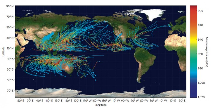
A new study looking at the economic costs of tropical cyclone damage taking into account climate change, forecasts that tropical cyclones will cause $109 billion in damages by 2100. Increased vulnerability of populations and growing economic wealth is expected to double the costs from $26 billion per year to $56 billion by 2100. Climate change is predicted to add some $53 Billion in damages. Two countries are responsible for incurring 75% of the extra damage from climate change associated with tropical cyclones: the United States and China. But tropical island nations will incurr the highest damage per GDP - up to 37%.

The study - The impact of climate change on global tropical cyclone damage - is by Robert Mendelsohn, Kerry Emanuel, Shun Chonabayashi & Laura Bakkensen from Yale and MIT and was published in Nature Climate Change on January 15, 2012.

Caption: Storm tracks and minimum pressure for a sample of synthetic storms. The tracks show that storms are more frequent in the western Pacific. The minimum pressure (hpa) or storm intensity is measured by their color. Storm intensity is higher over the warm waters near the Equator and lower over the cooler waters towards the poles.

Extreme weather: Heavy rain and flooding in Fiji tests climate disaster preparedness


Fiji is experiencing heavy rain and major flooding with a 15-day state of emergency being declared in Fiji’s west coast areas. At least 8 people have died so far in the Fiji January-February 2012 floods with up to 51 reported cases of water-related diseases, thousands in evacuation centres and $30million in damages reported so far.

The Government’s Provincial Development and Multi Ethnic Affairs Ministry Permanent Secretary, Colonel Inia Seruiratu, declared the emergency on January 25 to apply to Ba, Lautoka, Nadi, Nadroga, Ra, and Tavua.

A 2009 publication produced by UNISDR and the UN Development Programme (UNDP) warned that in western Fiji, high-intensity floods would become more frequent. In the Nadi area, for example, these type of floods used to occur every 190 years, but with the influence of climate change by 2100 it is projected that they will occur every 25 years. (Institutional and policy analysis of disaster risk reduction and climate change adaptation in Pacific Island Countries: final report (PDF))

Sunday, December 18, 2011

Extreme Weather: Flash flooding kills over 1000, displaces 100,000 in the Philippines

Heavy rain and flash flooding on Friday night and Saturday in the Philippines associated with tropical cyclone Washi, known locally as Sendong, has killed 521 people, with many still missing and unaccounted for, and displaced over 100,000 people. The cities of Cagayan de Oro and Iligan were particularly hard hit.

Tropical Storm Washi dumped on the island of Mindanao more than a month of average rains in just 12 hours. According to weather forecaster Leny Ruiz the records show that storms that follow Washi's track come only once in about 12 years. Officials claim it was one of the most destructive calamities in southern Philippines in recent years and struck areas not used to severe flooding. River flooding was worsened by the high tide.

Update 23 Dec 2011 - Latest report from AFP say that more than 1,000 people dead and another 1,000 missing, with about half a million people affected and 50,000 in evacuation centres.
Update 29 Dec 2011 - media release Climate Justice Activists Demand Justice for the Victims of Sendong

Wednesday, November 23, 2011

Extreme weather, risk management and adaptation in a warming climate - latest IPCC report

Over the weekend the Intergovernmental Panel on Climate Change (IPCC) released the Special Report on Managing the Risks of Extreme Events and Disasters to Advance Climate Change Adaptation (SREX). There were no surprises for anyone who follows climate science, and the report succinctly integrates a discussion of vulnerability, risk management and adaptation strategies for extreme weather disasters.

The report looks at the evidence for each extreme weather event and gives an assessment of probability and confidence value of each weather event assessment and the future trend. It involved some 220 expert authors from 62 countries and involved more than 18,000 review comments.

Saturday, October 29, 2011

Climate change, Water Security and drought in the Mediterranean region


A new study by NOAA - the US National Oceanic and Atmospheric Administration - has highlighted that climate change is a major contributor to more frequent Mediterranean droughts. According to the study in the last 20 years, 10 of the driest 12 winters have taken place in the lands surrounding the Mediterranean Sea. Water security, food security, and increasing wildfire frequency and intensity has the potential to destabilize the region producing conflicts over use of increasingly scarce water resources.

"The magnitude and frequency of the drying that has occurred is too great to be explained by natural variability alone,” said Martin Hoerling, Ph.D. of NOAA’s Earth System Research Laboratory in Boulder, Colorado, lead author of a paper published online in the Journal of Climate this month. “This is not encouraging news for a region that already experiences water stress, because it implies natural variability alone is unlikely to return the region’s climate to normal.”

Saturday, July 9, 2011

Scientist: Less rain across southern Australia a long term climate trend

Increasing atmospheric carbon dioxide concentrations is increasing atmospheric temperatures changing the dynamic of the sub-tropical jet stream and thus the number and intensity of storms bringing autumn and winter rainfall to southern Australia, according to CSIRO climate scientist Dr Jorgen Frederiksen. He was addressing the International Union of Geodesy and Geophysics conference in Melbourne this week regarding recent research on changes to atmospheric circulation, storm intensity and reduction in winter rainfall in Australia.

Warming Arctic air temperatures causing less snow, more rain, faster ice melt

Arctic air temperatures are warming faster than anywhere else on Earth. Although the level of precipitation is remaining unchanged, there is reduced snowfall in summer which is being replaced by increasing rain. The loss of summer snow and increase in rain is resulting in a positive feedback mechanism increasing warming and melting of the Arctic ice.

We are already witnessing an increase in the Albedo feedback mechanism - loss of reflectivity in the arctic leading to more warming and greater ice melt. Research published early in 2011 revealed Loss of reflectivity in the Arctic is double the estimate used in climate models. With the change in precipitation we have a further feedback mechanism contributing to Arctic warming and melting of snow and sea ice.

Wednesday, June 22, 2011

Climate change blamed in extreme shift from drought to flood in China


An extreme shift in weather in June across much of southern and eastern China has been put down to the effects of global warming and climate change. Usually light rains start in June in the middle and lower Yangtze valley leading in to the summer monsoonal rains and typhoon season, but this year torrential rains and storms struck on June 3 and have continued unleashing devastating floods, the worst in over 50 years.

Chen Zhenghong, senior engineer at the Meteorological Bureau of Central China's Hubei province, said the sharp shift between drought and flood in East and Central China was a result of global warming, according to a Xinhua News Agency report in China Daily on 17 June.

Sunday, February 6, 2011

Severe Torrential rain in Melbourne, Heatwave in Sydney


Over Friday night and Saturday morning Melbourne and Victoria suffered severe torrential rain and flash flooding setting some new rainfall records. The rain was generated from ex-cyclone Anthony and ex-cyclone Yasi. 200 millimetres in of rain was dumped in some Melbourne suburbs in just two hours. Some of the roads in the Melbourne CBD were rivers of water when the deluge began just after 7pm on Friday.

The rain was a result of extreme storm activity generated by and drawing down moisture from Tropical Cyclone Yasi now in Central Australia after devestating the coastal towns of Tully and Innisfails leaving 180,000 houses without power and a trail of destruction across Queensland. Melbourne and many Victorian towns suffered flash flooding and were also put on flood alert.

Sunday, January 16, 2011

2010 wettest year on record globally, and the wettest for Queensland


2010 was the wettest year on record globally according to the US National Oceanic and Atmospheric Administration (NOAA) with Australia experiencing it's wettest September on record, and the wettest year for Queensland with annual rainfall double the average.

La Nina is associated with flooding rains in South Asia, Australia, Brazil and central America. Not only Queensland and Brisbane has felt the force of La Nina, one of the strongest on record. Heavy rain and record flooding has also occurred in Victoria. Overseas, La Nina has brought torrential rains, flooding and mudslides to Brazil killing over 600 people, to Sri Lanka killing 38 and displacing over a million people, and in the Philippines killing 42 people.