Mastodon Climate Citizen --> Mastodon
Showing posts with label cyclone. Show all posts

Thursday, April 13, 2017

Adani's Abbot Point coal contamination of Caley Valley wetlands and marine environment


Article First published at nofibs.com.au

Adani's coal export terminal at Abbot Point was in the direct path of Category 4 Cyclone Debbie. There was reason to expect a large storm surge, but this did not occurr, but the destructive winds and torrential rain caused Adani to release a large amount of contaminated water into the adjacent wetlands and ocean.

On Sunday April 9 the Mackay Conservation Group published on their facebook page a before and after photo of the Abbot Point export coal terminal owned by Adani, and part of the Caley Valley wetlands adjacent to it.

Thursday, March 30, 2017

Greens dare criticize coal and climate policies during #CycloneDebbie


Original article published at nofibs.com.au

Those uppity Greens are daring to speak about climate change while severe Tropical Cyclone Debbie beat the shit out of the Whitsunday Islands (Read this report of Hamilton Island), Proserpine and Bowen, and now threatens extensive flooding from torrential rainfall for central and SE coastal Queensland.

The accusatory tone from Malcolm Turnbull and other Liberal government ministers is 'How dare you try to politicise an extreme weather event, when we should all be pulling together.', while they conveniently forget the South Australian storms in September 2016 which resulted in a system black which they conveniently and erroneously immediately blamed on the fault of the wind turbines in South Australia.

They have continued to prosecute an attack on wind energy and South Australia, despite a BOM report blaming the primary cause as the cyclonic storm with 260km per hour wind gusts. AEMO also put the primary cause as the destructive winds destroying transmission towers, but also identified in the final report that automatic wind generator protection settings (since updated) contributed to the System Black event.

No pulling together for South Australia, Queensland, or in fact all of Australia, in it's time of need to resolve the lack of coherence in energy and climate policies.

Is there the taint of hypocrisy here? You bet.

Sunday, March 26, 2017

Coral, climate change, storm surges and #CycloneDebbie


Article originally published at nofibs.com.au

Tropical Cyclone Debbie is forecast to cross Central Queensland coast on Tuesday morning as a Category 4 Severe tropical cyclone. It will bring destructive winds greater than 200km per hour plus a storm surge with a king tide innundating low lying coastal properties, and torrential rain causing flooding. It is also cooling sections of the Great Barrier Reef reducing coral bleaching from an extensive and long lasting marine heatwave.

Update: 25,000 people in Mackay ordered to evacuate due to storm surge threat.
Update: Coal mines and coal ports affected.

Tropical Cyclone Debbie draws heat from the unusually warm waters of the Coral Sea. This will help it increase in intensity to achieve possibly Category 4, and an outside chance as a Category 5 severe tropical cyclone before it strikes land.

It is the first tropical cyclone to strike the north Queensland coast since Cyclone Nathan in March 2015. Although it may not be as strong, it is being compared in size and extent to the Category 5 cyclone Yasi from 2011.

Tuesday, August 25, 2015

Reflecting on Hurricane Katrina 10 years on


I wrote this in response to a facebook discussion on whether Hurricane Katrina can be attributed to climate change. It is an argument I put together with limited time and research, but still valuable to answer the question..

Monday, March 16, 2015

Severe Tropical Cyclone Pam devastates Vanuatu and other Pacific Island nations


Tropical Cyclone Pam, a category 5 storm as measured on both the Australian and Saffir-Simpson storm measurement scales, with wind gusts over 300km/hr, has devastated the Pacific Island Nation of Vanuatu.

The storm made a direct hit on the capital Port Vila of this island country on Friday night and the early hours of Saturday morning, causing widespread damage, blocking roads, power and communication outages and destroying many homes and buildings. Even the main Hospital in Port Vila suffered damage.

Tom Skirrow from Save The Children says 10,000 people need emergency shelter in Port Vila alone according to Liam Fox, an ABC News Pacific Affairs Reporter. According to Radio New Zealand (@RNZNews) Vanuatu's Disaster Management Office says part of the country's main hospital, Vila Central, have been destroyed. This has been confirmed by Vanuatu's lands minister, Ralph Regenvanu, saing only one ward of Vila Central Hospital is still operational.

The United Nations Relief web reported:
The cyclone was one of the strongest ever recorded in the Pacific Islands with sustained winds of 270km/hr gusting to 360km/hr. The United Nations has stated that Pam could be one of the worst natural disasters in the history of the Pacific. Vanuatu’s President, Baldwin Lonsdale, has appealed to the global community for help. Thousands of people are in temporary shelters. Entire communities were severely damaged in some areas. Islands in the north and south of Vanuatu were hit most directly.

Thursday, February 19, 2015

Extreme Weather: Severe Tropical Cyclones Lam and Marcia make Australian landfall

Double Trouble: Two severe tropical cyclones are converging on the Australian coast. Tropical Cyclone Marcia developed in the Coral Sea off the Queensland Coast. Tropical Cyclone Lam developed in the warm waters of the Gulf of Carpentaria before moving north and west into the Arafura Sea.

This map from bureau of Meteorology shows Tropical Cyclone Lam hitting the Northern Territory and Tropical Cyclone Marcia about to make landfall between Mackay and Yeppoon on the Queensland coast.

Severe Tropical cyclone Marcia is the 4th recorded category 5 storm to make landfall on the Queensland coast. Previous category 5 storms included Cyclone Yasi in 2011, Cyclone Innisfail in 1918 and Cycline Mahina in 1899. See a list of Australia's worst tropical cyclones at Australian Geographic.

Follow the live reporting at the Brisbane Times or live reporting at the Guardian.

Friday, February 28, 2014

Harnessing the wind to fight the storms of climate change

How Offshore wind turbines can win a david and goliath battle with hurricanes. Here is a lateral idea: build large offshore wind farms that provide electricity from day to day, but also substantially decrease damaging hurricane or tropical cyclone wind speed and storm surge.

With tropical cyclones forecast to grow stronger and more intense with climate change, if not in greater frequency, such an idea has definite merit to explore. Climate change is predicted to escalate Tropical Cyclone / hurricane damage costs particularly for US and China.

We wouldn't need to put offshore wind farms right along the coast, perhaps just where they can be most effective at lessening storm damage to human lives and infrastructure. And allow us to plant mangroves and cultivate coastal wetlands to store carbon, and provide fish nursery habitat, and absorb storm surges, rather than hugely expensive rock and concrete sea walls.

Sunday, January 5, 2014

Sea surface temperatures unusually warm around Australia in 2013

Sea surface temperatures around Australia in 2013 were unusually warm reported the Australian Bureau of Meteorology in it's annual climate statement. Record ocean temperatures were recorded for January and February, with November the second-highest on record. This continues a long term trend for increasing sea surface temperatures around Australia and globally.

Updates:

Sunday, November 10, 2013

Super typhoon Haiyan strongest on record with over 10,000 feared dead in Philippines


On the eve of the annual United Nations Framework Climate Change Convention (UNFCCC) meeting in Warsaw Poland, an extreme weather disaster has struck the Philippines with record-breaking Super-typhoon Haiyan (known locally as Yolanda), bringing devastating winds and storm surge.

Over 10,000 people are feared dead ,according to several media reports like this one in the Sydney Morning Herald, just in the province of Leyte, where the regional city of Tacloban, population of 221,000, was right in the path of the northern hurricane eye wall experiencing the full ferocity of destructive winds and tsunami like storm surge of over 5 metres.

The city has been estimated as 95 per cent devastated, with massive building destruction and damage, and substantial casualties, with people requiring emergency food and water supplies.

Sunday, September 22, 2013

Super Typhoon Usagi drawing energy from record warm waters

Super Typhoon Usagi is the strongest tropical cyclone storm on a global level this year, bringing destruction to the Northern Philippines, Taiwan, Hong Kong and southern China.

Warmer surface waters contribute energy for much stronger, more intense storms. Parts of the Western Pacific have experienced record and much warmer than average sea surface temperatures in August, part of record global sea surface temperatures.

A NASA analysis of the storm remarked on it's super rapid intensification, identifying warm ocean waters as a contributor to the storm's rapid growth and strength.

Monday, May 13, 2013

Climate change fuelling more Hurricanes for Hawaii by end of century

A recent study looking into regional tropical cyclone formation conditions in the east and central Pacific has projected that 2 to 3 times more tropical cyclones (Hurricanes) are likely to hit Hawaii in the later part of this century.

While on a global level tropical cyclones are expected to slightly reduce in frequency overall, because of regional conditions some areas will actually experience an increase in tropical cyclone frequency. Hawaii happens to be one of those areas.

Related: Climate change predicted to escalate Tropical Cyclone damage costs for US and China

Wednesday, December 26, 2012

Increase in cyclone frequency in Indonesia blamed on climate change

Cyclone frequency in Indonesia in 2012 is 28 times that for the year 2002, according to the Indonesian Disaster Management Agency BNPB, with the increase attributed to the persistent impact of systemic climate change.

Indonesia straddles the equator on the edge of two important cyclone generating basins: the West Pacific basin, which can affect the eastern part of the country, and Indian Ocean basin, which affects the western and southern regions of Indonesia.

Sutopo Purwo Yuwono, spokesperson with the Indonesian disaster management agency (Badan Nasional Penanggulangan Bencana) BNPB told the Xinhua newsagency, "Global warming has resulted in the formation of more cumulonimbus clouds that could incite cyclones,"

Sutopo went on to predict that more cyclones would hit in Indonesia in March to April next year. Floods and landslides are expected to strike from January to March.

Friday, December 14, 2012

Extreme Weather: Tropical Cyclone Evan pounds Samoa and Fiji

Updated 19 December, 2012: The tropical paradise of Samoa in the South Pacific has been lashed with gale force winds, flash flooding from torrential rain and a 3 metre storm surge from Category 2 tropical cyclone Evan on Thursday and Friday. After two days the tropical cyclone is now moving west and intensifying as it heads in the direction of Fiji. Wallis and Fortuna Islands also lie directly in the storm path and northern atolls of Tonga may also be affected to some degree.

The cyclone arrived with little warning at Samoa on Thursday morning, December 13, pounding the islands. Up to 4,000 people were forced to evacuate their homes and villages and took refuge in evacuation centres in schools and church halls.

On Thursday afternoon Samoan Deputy Prime Minister and Acting Chairman of the National Disaster Council, Fonotoe Pierre Lauofo, made a “declaration of disaster” on the national radio.The cyclone was still near Samoa's Upohu island on Friday causing waves of up to 6 metres.

While Fiji waits for Evan to hit on Sunday, a massive cleanup had started in Samoa to assess the extent of the damage to infrastructure, restore power and rebuild after the destruction wrought by the cyclone.

Saturday, December 8, 2012

Death toll from Typhoon Bopha rises as Philippines climate negotiator appeals for action


A week ago Category 5 tropical cyclone Typhoon Bopha (Locally known as Pablo) slammed into the Philippines island of Mindinao bringing death and destruction. The Typhoon storm track was the most southerly tropical cyclone ever recorded in the western Pacific and the strongest to hit the Philippines this year. The Philippines is subjected to typhoons on a regular basis, but systematic climate change is making them more intense and changing their paths of destruction.

Naderev Saño, head of the Philippines climate delegation at the Doha UNFCC climate talks described to Democracy Now, "The path of Typhoon Bopha is slightly more to the south of what struck Mindanao last year, but it is affecting the same areas. And it is sobering for us to know that a typhoon like this, that normally doesn’t hit that part of the country, in fact, this is a — in half a century, this is the first time that a typhoon that has crossed as south as Bopha."

The storm's high winds and torrential rain caused flash flooding in several provinces in the island of Mindanao in the southern Philippines. Compostela Valley and Davao Oriental in eastern Mindanao were particularly hard hit. The town of New Bataan in Compostela Valley has been obliterated by raging floodwaters. Communications to many areas were cut as roads and bridges were destroyed. The death toll approaches 500 with some 170,000 displaced people.

Update 8 December: Typhoon Bopha has turned back on the Philippines in the South China Sea and is expected to slam into the northern tip of the main island of Luzon on Sunday, threatening the Ilocos provinces and La Union area. The Typhoon has maintained it's intensity with maximum sustained winds of 130 kph near the center and gustiness of up to 160 kph with estimated rainfall amount from 15 to 25 mm per hour (heavy - intense) within the 400 km diameter of the Typhoon.

A state of national calamity has been declared by President Benigno Aquino to speed up the release of funds for rescue and retrieval operations.

Related: Landslide Blog - Evaluating the causes of the Typhoon Bopha / Pablo disaster | The Free - Climate Chaos caused Bopha/Pablo. Oil Companies to be Sued ??

Friday, November 2, 2012

Crops devastated, food crisis looms in Haiti from Hurricane Sandy


At least 54 people were killed by Hurricane Sandy in Haiti due to the torrential rains, flooding and destruction of essential bridges and roads. Many Concrete homes and tent camps in Port-au-Prince setup after the 2010 earthquake are largely destroyed leaving up to 18,000 families homeless according to Haitian authorities.

Substantial crop loss occurred due to the Hurricane winds and flooding, threatening hunger and famine in coming weeks and months. Staple crops such as bananas and breadfruit were severely damaged by hurricane Sandy. "We'll have famine in the coming days," Kechner Toussaint, the Abricots mayor, reportedly said. "It's an agricultural disaster."

Related: Superstorm Sandy a wakeup call on climate change for the USA? | UN Reliefweb: UN relief agency estimates 1.8 million Haitians have been affected by Hurricane Sandy

Superstorm Sandy a wakeup call on climate change for the USA?

Hurricane Sandy on October 29. Courtesy: NASA


In the three presidential debates between Mitt Romney and Barak Obama climate change was never mentioned, despite it being raised in all previous campaigns going back to 1988. And then came Hurricane Sandy from the Caribbean. A late season category 1 tropical cyclone that combined with a north-easter from the Arctic to pummel the northern eastern coast of the United States, one of the most populous and industrialised areas on earth.

The Hurricane crossed the coast in New Jersey on Monday night, 29 October, at about 8pm not far from Atlantic City. The storm surge caused widespread areas flooded leaving coastal towns decimated. The winds of the hurricane caused trees to fall and whipped up a massive 3 to 4 metre storm surge. A full moon and a spring tide also exacerbated the storm surge. 10 metre waves were measured just outside New York Harbour entrance. (See Accuweather Superstorm Sandy Stats)

Related: Skeptical Science - Hurricane Sandy and the Climate Connection | Crops devastated, food crisis looms in Haiti from Hurricane Sandy | Inside Climate News: 3-D Maps Pictured Sandy's Devastation–Five Years Ago

Saturday, February 4, 2012

Climate change predicted to escalate Tropical Cyclone damage costs for US and China

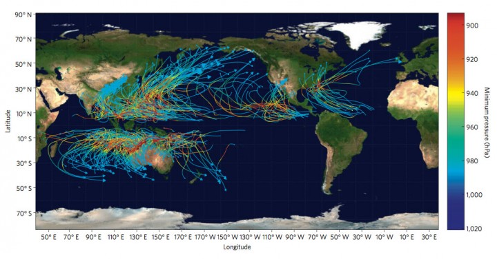
A new study looking at the economic costs of tropical cyclone damage taking into account climate change, forecasts that tropical cyclones will cause $109 billion in damages by 2100. Increased vulnerability of populations and growing economic wealth is expected to double the costs from $26 billion per year to $56 billion by 2100. Climate change is predicted to add some $53 Billion in damages. Two countries are responsible for incurring 75% of the extra damage from climate change associated with tropical cyclones: the United States and China. But tropical island nations will incurr the highest damage per GDP - up to 37%.

The study - The impact of climate change on global tropical cyclone damage - is by Robert Mendelsohn, Kerry Emanuel, Shun Chonabayashi & Laura Bakkensen from Yale and MIT and was published in Nature Climate Change on January 15, 2012.

Caption: Storm tracks and minimum pressure for a sample of synthetic storms. The tracks show that storms are more frequent in the western Pacific. The minimum pressure (hpa) or storm intensity is measured by their color. Storm intensity is higher over the warm waters near the Equator and lower over the cooler waters towards the poles.

Sunday, January 1, 2012

Extreme Weather: Cyclone Thane hits India

One of the last tragic extreme weather events of 2011 was Cyclone Thane hitting the Tamil Nadu coast of India. It caused 46 deaths and damaged buildings, roads and crops. It was the strongest tropical cyclone of 2011 within the North Indian Ocean.

Image from NOAA - Cyclone Thane in the Bay of Bengal
on 28 December 2011, taken by Meteosat


From the Bay of Bengal it made landfall as a very severe cyclone on Friday 30 December very close to Puducherry. The storm struck with torrential rains and gale force winds from 125 to 140 kilometres per hour which uprooted hundreds of trees and knocked down electric poles and mobile phone towers producing power outages and communications blackouts in several areas.

A recent study linked increasing air pollution over the Indian sub-continent to an increase in the intensity of Tropical cyclones in the region.

Cyclone Intensity in North Indian Ocean linked to increasing air pollution

A recent study linked increasing air pollution over the Indian sub-continent to an increase in the intensity of Tropical cyclones in the Arabian Sea. The air pollution over the Indian sub-continent changes wind circulation patterns reducing wind shear in the Northern Indian Ocean providing more potential for intense cyclones to form. This is combined with warm sea surface temperatures in the region, especially in the Bay of Bengal, to provide the conditions for more intense and destructive cyclones.

Image by NASA Earth Observatory - Category 4
Tropical Cyclone Gonu in the Arabian Sea in 2007

Tuesday, December 27, 2011

Cyclone frequency declining while intensity increasing across Australian and Pacific region: CSIRO

New research by CSIRO scientists is showing a trend for fewer tropical cyclones forming off the Western Australian coast, but those that do form may become more intense and potentially destructive. The results apply across the Australian region according to CSIRO in an interview with Dr Debbie Abbs from CSIRO Marine and Atmospheric Research published on December 21, 2011.

Dr Debbie Abbs said there could be a 50 percent reduction in the number of storms in the second half of this century – from 2051-2090 – compared to the period from 1971-2000. The climate model developed by Dr Abbs' team also indicates a distinct shift towards more destructive storms. "Despite a decrease in the number of tropical cyclones, there is a greater risk that a tropical cyclone that forms will be more severe in future," Dr Abbs said. "Even a small increase in cyclone intensity is concerning because of the threat to life, property, industry and agriculture,” said Dr Abbs in a CSIRO media release.