Mastodon Climate Citizen --> Mastodon
Showing posts with label rainfall. Show all posts

Tuesday, March 11, 2025

Prime Minister Albanese says global warming a factor in Tropical Cyclone Alfred and its extreme weather impacts

So on Friday while Category 2 Cyclone Alfred drifted near the Queensland coast, Prime Minister Anthony Albanese fronted up to a media conference in Canberra with questions on whether global warming is making disasters worse, whether the 2035 emissions reduction targets will be released prior to the election (which is a commitment under the UNFCCC and Paris Agreement, not Australian law) and on Peter Dutton choosing to attend an event in Sydney than help constituents in his Brisbane electorate of Dickson prepare for the extreme weather impacts of the cyclone event.

While the Tropical Cyclone stalled over Moreton Bay becoming a tropical Low, it still brought substantial wind damage, and intense rainfall to large parts of SE Queensland and the Northern Rivers of NSW causing extensive flood emergencies. At its peak, more than 450,000 households in SE Queensland and Northern NSW lost power from the grid. Premier Crisafulli described it as the "largest ever loss of power from a natural disaster in Queensland's history". On Sunday several sites around Brisbane set new daily rainfall records.

The Queensland and NSW Governments, along with the Federal Government had been quick to prepare and warn citizens, and set in place emergency services to respond the the extreme weather impacts.

The Climate Council and independent rapid attribution climate researchers identified that global warming is a factor for Tropical Cyclone Alfred as it approached Brisbane.

Wednesday, January 10, 2024

Victorian Premier Jacinta Allan acknowledges climate change a factor in extreme rain and flood events

Premier Jacinta Allan has acknowledged that climate change is a factor in extreme rain and flood events, and that more needs to be done in planning to mitigate extreme weather and flood events as part of climate adaptation, along with reducing greenhouse gas emissions.

The Bureau of Meteorology has identified the first nine days of 2024 were Victoria’s wettest since records began in 1900, with an average of 62mm falling across the state since 1 January. The area-average of 62mm of rain from 1 January to 9 January beat the previous opening nine-day record of 50mm set in 1970. Using an area average for daily rainfall to 9am 8 January, the Bureau of Meteorology estimated 5.4% of Victoria was at Highest on record for rainfall for that day, with several site specific all time rainfall records surpassed. 

Interviewed by Richard Willingham on ABC Melbourne, Premier Jacinta Allan said; 

"There is clearly a change in our climate. Growing up in this part of the world, these summer storm events, it is troubling that it is becoming more common and the ferocity of these events. It does speak to the fact we need to recognise that the climate is changing. It does go to those broader measures we need to take as a government, as a community, as a society for action to transition to renewable energy, transition to how we can take stronger climate action."

"Separate to that, what also needs to be considered obviously as we plan for new houses, new communities, or how we build projects, these weather events and the impact of these weather events do need to be factored in. Indeed, legislation that went through the Victorian Parliament last year, our climate legislation, did require that the impact of the climate be factored into the planning initiatives at the earliest Opportunity."

".... What used to be a 1 in 100 year event for communities like Rochester have had 3 big flooding events in 10-11 years. The impact of climate does need to be considered in terms of future planning and decisions."

Thursday, February 3, 2022

Sleepless in Melbourne - heat, humidity and rainfall set new January records for Victoria

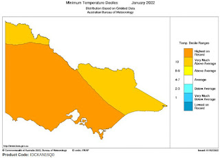
BOM: Average Tmin deciles for January

Sleepless in Melbourne? January was a warm one for Melbourne despite presence of La Nina (ENSO) which usually cools global temperatures marginally. 

The trend was particularly noteable with record mean minimum temperatures for Melbourne and most of Victoria this year. Victoria's January mean minimum temperatures are rising faster than mean maximum temperatures. 

There was also record humidity for January for most of Victoria. Record rainfall was also recorded in north east Victoria.

It seems there will be lots more sleepless January nights in store for us all in Melbourne in future years.

Friday, January 11, 2019

2018 third hottest on record for Australia with protracted drought, persistent heat


Australia's average temperature in 2018 was 1.14 °C above the 1961–1990 average, making it slightly warmer than 2017 said the Bureau of Meteorology in the 2018 Annual climate statement.

"When we look across all of Australia in 2018, we can see that every single state and territory had above-average day and night-time temperatures," Dr Bettio said.

"The average maximum temperature for the country as a whole was particularly warm, sitting 1.55 °C above the 1961–1990 average, making 2018 Australia's second warmest year on record for daily high temperatures.

"Average minimum temperatures for 2018 were 0.73 °C above average, the eleventh-warmest on record.

"The only part of the country to buck the trend for above average temperatures was the Kimberley region, which had cooler than average nights for the year."

On temperatures 2018 was Australia's third-warmest year on record; a year of protracted drought and persistent warmth.

Meanwhile, Australia still has no effective climate or energy policy, no consistent plan to phase out coal or gas fossil fuels, no plan to reduce transport emissions, a problem with increased vegetation clearing in Queensland and New South Wales. Australia's emissions are rising over the last 4 years and Environment department Data shows that Australia is unlikely to meet it's low 26 percent emissions reduction target by 2030.

Wednesday, November 7, 2018

Storms and flooding for Melbourne Cup day, but media dares not mention climate change


Melbourne Cup day dawned with rain falling. Storms escalated with torrential rain through the morning. Power outages, train disruptions, flashflooding of stations and many low lying roads across the city eventuated. But the mainstream media failed to add 2 + 2 with the influence of climate change in this extreme weather event.

The previous day racing officials had ordered more racetrack irrigation overnight to reduce the firmness of the track. Perhaps they should have checked the weather forecast.

Intense rain events are becoming more frequent, the science is clear not only from models but also observational data. Part of the reason for this is a Warmer atmosphere that can carry more moisture. For every 1 degrees Celsius of warming the extra atmospheric carrying capacity is increased by an extra 6-7 per cent. So heavier rain. That means more flash flooding.

Thursday, March 30, 2017

Greens dare criticize coal and climate policies during #CycloneDebbie


Original article published at nofibs.com.au

Those uppity Greens are daring to speak about climate change while severe Tropical Cyclone Debbie beat the shit out of the Whitsunday Islands (Read this report of Hamilton Island), Proserpine and Bowen, and now threatens extensive flooding from torrential rainfall for central and SE coastal Queensland.

The accusatory tone from Malcolm Turnbull and other Liberal government ministers is 'How dare you try to politicise an extreme weather event, when we should all be pulling together.', while they conveniently forget the South Australian storms in September 2016 which resulted in a system black which they conveniently and erroneously immediately blamed on the fault of the wind turbines in South Australia.

They have continued to prosecute an attack on wind energy and South Australia, despite a BOM report blaming the primary cause as the cyclonic storm with 260km per hour wind gusts. AEMO also put the primary cause as the destructive winds destroying transmission towers, but also identified in the final report that automatic wind generator protection settings (since updated) contributed to the System Black event.

No pulling together for South Australia, Queensland, or in fact all of Australia, in it's time of need to resolve the lack of coherence in energy and climate policies.

Is there the taint of hypocrisy here? You bet.

Wednesday, June 8, 2016

Different responses to Extreme rainfall and flooding from France and Australia


Updated: 10 June 2016: Details of climate attribution of French extreme rainfall and flood event

Over the last week we have seen extensive flooding around central France and southern Germany, and the impact of an East coast Low on Australia. They are different weather events but they share a certain commonality in being disastrous intensive rainfall and flood events resulting in death and damage.

The French extreme rain and flood event has recently been attributed to climate change, while the extreme nature of the East Coast Low has not yet been studied for event attribution. Attributing single events to climate change can be statistically difficult due to the range of climate variability. The damage and destruction of both events are consistent with increasing climate trends of greater intensity of rainfall and flood events around the world due to climate change.

While Prime Minister Turnbull and Opposition leader Shorten stayed well clear of mentioning climate change with regards to the extreme rainfall and flooding event in Australia, the French President was far less circumspect, exclaiming (fr) at a press conference that the extreme rainfall and flooding event in France emphasized the importance of the fight against global warming.

"When there are climatic phenomena of this severity, we must all be aware that it is across the world that we must act," he added. "The weather of this magnitude, with people who have been forcibly displaced with emergency relief interventions necessary, is not just a phenomenon that affects only France. It also concerns victims in Germany and Poland," he noted during a press statement with Chilean President Michelle Bachelet.

Saturday, January 11, 2014

Climate Geo-engineering study on sulphate injection shows Hydrological disruption to rain and severe drought

While politicians have effectively dithered on robust action to reduce greenhouse gas emissions over the last 20 years we are hearing more about geo-engineering proposals to moderate rising temperatures. But the latest study from the University of Reading scientists modelling solar radiation management, and in particular atmospheric aerosol injection - one of the easiest geo-engineering proposals to do at large scale - says such a project would result in a major decrease in tropical rainfall and an increase in drought in many regional areas.

The Reading University study concentrated on the consequences on geo-engineering methods to change the solar radiation reaching the earth: through mirrors above the atmosphere; and injecting sulfate aerosols into the atmosphere to reflect solar radiation. The first could prove hideously expensive and is at the moment impractical, but the second method is quite achieveable at reasonable cost.

The study - Weakened tropical circulation and reduced precipitation in response to geoengineering (Full paper) - looks at aerosol injection in particular and the projected impacts. It was published in Environmental Research Letters.

Related: Yale Environment360: Solar Geoengineering: Weighing Costs of Blocking the Sun’s Rays (9 Jan 2014)

Thursday, October 10, 2013

Colorado extreme rainfall and flood event of 2013


Like many people around the world I watched and followed the astonishing rainfall and flood events in Colorado in September this year that resulted in at least 10 deaths, damaged some 18,000 homes, caused the evacuation of more than 10,000 people, washing away roads and bridges and isolating communities for a time. The rain and flood event is estimated to have caused $2 billion worth of damage.

The extent of the rainfall was unprecedented in meteorological records that stretch back a little more than 100 years. The extreme rainfall event has been described as a 1 in 1,000 year event. An Extremely rare combination of weather factors combining to produce the event.

Climate change however stacks the dice in several ways in increasing the probability of this event occurring in the future. A primary contribution is the increase in atmospheric capacity to carry water vapour which scientists have worked out to be 6 per cent to 7.5 per cent for each degree Celsius in average global warming. By the end of this century with average global surface temperatures projected to increase by 4 to 5 degrees with current business as usual scenarios, the atmospheric carrying capacity may be an extra 30 per cent, making extreme precipitation events like the Colorado event much more likely to occur.

Tuesday, March 12, 2013

Melbourne heatwave a sizzling autumn end to an angry summer

Melbourne is setting another temperature record: the longest number of days of any month where the maximum temperature exceeds 30 degrees Celsius.

Monday was the 8th consecutive day of above 30C heat with a forecast of at least two more days of temperatures in the mid 30s. That will make 10 continuous days before a cool change is expected late on Wednesday brings down temperatures to a milder high 20s.

The previous record for any month was 8 continuous days set in February 1961. For the month of March, seven consecutive days above 30C is the record set in 1995.

The average temperature in Melbourne during March is 23.9C. The hottest March on record was 1940 with an average of 28.9C which we may well be on track to exceed this year.

And if you were tossing and turning in bed due to the heat, here is the reason: Melbourne experienced it's warmest March night on record on Tuesday night (12/3) according to a news report. Temperatures fell to a minimum of 26.5 degrees. The previous record was a minimum of 26.3 degrees set back in 1927.

Yes - the long term trend just keeps getting hotter. But we have had autumn heat waves before, they just weren't as long.

Related: The Bureau of Meteorology have issued a special climate statement on the Autumn heatwave: A prolonged autumn heatwave for southeast Australia (PDF) The statement was issued 15th of March 2013

Saturday, January 26, 2013

Torrential rain, tornados on Queensland coast causing flash flooding and damage

Monday night: Significant flooding events are ocurring at Bundaberg, Gympie, Maryborough, Ipswich, Warwick and in the Lockyer Valley. Rockhampton is expecting significant flood from the Fitzroy river on the weekend. There have been four deaths so far confirmed and two people missing. Nearly 180,000 properties across SE Queensland are still without power Monday night reports Energex. Storm system now bringing torrential rain and flooding to NSW coast, expected to be over Sydney Tuesday dawn and the Illawarra during Tuesday morning before heading out to sea.

In Bundaberg the Burnett River is at 9.2 metres and rising fast, with flow speeds of about 40knots (70km/hr). It is expected to peak at a record level of 9.5 metres late on Tuesday. There was mandatory evacuations carried out today affecting about 5000 people, with over 1500 people from 1000 properties are in evacuation centres. 16 helicopters were brought in, including 4 Black Hawks from the Australian Defence Force to rescue people from house roofs after flood waters rose rapidly today. Patients from Bundaberg hospital are being evacuated to Brisbane.

Sunday 6pm: Rain Likely to continue overnight then subside as the system moves south into NSW. Substantial flooding is occurring in Gladstone, Bundaberg, and Gympie much higher than the 2011 floods. Moderate flooding is expected Monday and Tuesday on the Bremer and Brisbane rivers with up to 3,600 Brisbane properties likely to be impacted, significantly less than the 2011 floods. Brisbane City Council have released flood maps for people to prepare. Flood waters will peak on Monday in Ipswich and Moggill and Tuesday night in Brisbane, where another peak is expected on Wednesday afternoon.

It was reported by Energex at 6.08pm Sunday 27 January that nearly 100,000 customers were without power in south east Queensland. By 7:48pm the number had climbed to 124,845. At 10:18pm 154,497 customers were without power. Just after midnight on Monday 12:28am power was off for 179,835 customers.

Related: Official alert information: QldAlert.com | Emergency QLD media releases | Climate change now affects all weather events

Saturday, January 5, 2013

England experiences wettest year on record, second wettest for UK

According to provisional data by the UK Met office 2012 was the second wettest year in the UK national record dating back to 1910, and just a few millimetres short of the record set in 2000. Four of the top five wettest years have now occurred since 2000. The year was the wettest year on record for England, and third wettest for Wales.

2012 saw Britain come out of one of the severest droughts on record in 2011. March was the driest for more than half a century leading to activation of hosepipe bans across much of England. While the year started dry it then set new rainfall records for the wettest April, and the wettest June for the UK causing widespread flooding.

The persistent wet weather resulted in total 2012 rainfall for the UK of 1330.7 mm, which is just 6.6 mm short of the record set in 2000.

Saturday, April 28, 2012

Global Warming intensifying Global Water Cycle by double current climate model projections

New research into ocean salinity levels has revealed a strong global water cycle intensification during the period of 1950 to 2000. The researchers report the rate of change in the global water cycle is double the rate projected by current-generation climate models. The study found "robust evidence of an intensified global water cycle at a rate of about eight per cent per degree of surface warming," said study co-author Dr Durack, a post-doctoral fellow at the Lawrence Livermore National Laboratory in the US.

Saturday, November 26, 2011

Pacific climate change: temperatures rise, sea levels increase, rainfall changing

A major new report on climate change in the Pacific Ocean region reports that the region is getter hotter, sea levels are rising, rainfall is changing and equatorial winds have weakened. While cyclone may tend to decrease slightly in the future, cyclone intensity is likely to be greater.

The report launched today - Climate change in the Pacific, scientific assessment and new research - contains 530 pages in 2 volumes with over 100 authors. The research was led by the Australian Bureau of Meteorology (BOM) and Commonwealth Scientific Industrial Research Organisation (CSIRO) with strong input from 15 National Meteorological Services, Geoscience Australia, and from universities in the region. The report includes observations and climate projections for 15 partner countries involved : Cook Islands, East Timor, Federated States of Micronesia, Fiji, Kiribati, Marshall Islands, Nauru, Niue, Palau, Papua New Guinea, Samoa, Solomon Islands, Tonga, Tuvalu, and Vanuatu.

Saturday, October 29, 2011

Climate change, Water Security and drought in the Mediterranean region


A new study by NOAA - the US National Oceanic and Atmospheric Administration - has highlighted that climate change is a major contributor to more frequent Mediterranean droughts. According to the study in the last 20 years, 10 of the driest 12 winters have taken place in the lands surrounding the Mediterranean Sea. Water security, food security, and increasing wildfire frequency and intensity has the potential to destabilize the region producing conflicts over use of increasingly scarce water resources.

"The magnitude and frequency of the drying that has occurred is too great to be explained by natural variability alone,” said Martin Hoerling, Ph.D. of NOAA’s Earth System Research Laboratory in Boulder, Colorado, lead author of a paper published online in the Journal of Climate this month. “This is not encouraging news for a region that already experiences water stress, because it implies natural variability alone is unlikely to return the region’s climate to normal.”

Saturday, July 9, 2011

Scientist: Less rain across southern Australia a long term climate trend

Increasing atmospheric carbon dioxide concentrations is increasing atmospheric temperatures changing the dynamic of the sub-tropical jet stream and thus the number and intensity of storms bringing autumn and winter rainfall to southern Australia, according to CSIRO climate scientist Dr Jorgen Frederiksen. He was addressing the International Union of Geodesy and Geophysics conference in Melbourne this week regarding recent research on changes to atmospheric circulation, storm intensity and reduction in winter rainfall in Australia.

Sunday, January 16, 2011

2010 wettest year on record globally, and the wettest for Queensland


2010 was the wettest year on record globally according to the US National Oceanic and Atmospheric Administration (NOAA) with Australia experiencing it's wettest September on record, and the wettest year for Queensland with annual rainfall double the average.

La Nina is associated with flooding rains in South Asia, Australia, Brazil and central America. Not only Queensland and Brisbane has felt the force of La Nina, one of the strongest on record. Heavy rain and record flooding has also occurred in Victoria. Overseas, La Nina has brought torrential rains, flooding and mudslides to Brazil killing over 600 people, to Sri Lanka killing 38 and displacing over a million people, and in the Philippines killing 42 people.

Thursday, December 30, 2010

Global warming a potent brew for coffee and tea drinkers

Okay, climate change is now getting serious with global warming set to impact on the enjoyment of a nice strong cup of Assam tea or a good brew of Columbian coffee. Already the subtle flavors of Assam tea are starting to change. For the tea and coffee connoisseurs in the developed world we might find the price increasing on that skinny latte or cup of tea.

While we might bemoan tea or coffee price rises from the comfort of our street cafes and comfortable dwellings, the real hardship will be felt by the thousands of small growers in the developing world who are dependent on tea or coffee as a major cash crop and boost to their local economies facing the problems of increasing temperatures and changing rainfall patterns.

Coffee and Conservation | Oxfam Fairtrade coffee campaign | FairTrade Tea | Youtube videos: Two degrees up - Part One: Columbia | Sri Lanka Tea and Drought

Monday, October 25, 2010

September 2010 was Australia's wettest in 111 years


The USA based National Oceanic and Atmospheric Administration (NOAA) National Climatic Data Center have stated that September 2010 was Australia's wettest month in 111 years of precipitation records being kept.

A moderate to strong La Niña event - known scientifically as El Niño-Southern Oscillation (ENSO) - in the tropical Pacific Ocean is bringing wetter conditions across much of eastern Australia, according to the Bureau of Meteorology. "La Niña is the flipside to the well known drought-producing El Niño. It usually brings wetter than average spring and summer conditions to much of eastern Australia" said the Manager of the NSW Climate Services Centre, Clinton Rakich.

Saturday, October 23, 2010

CSIRO: South East Australia becoming drier, Global Warming implicated


Caption: Figure 1. Rainfall deciles across Australia for 1 January 1997 to 31 December 2009; deciles based on climatology from 1900 to 2009 (Bureau of Meteorology) - from the report

A new report into the changing climate of South East Australia and particularly the Murray Darling Basin indicates an increasing risk of below average rainfall and runoff into streams and generally drier conditions. The change in the climate has, at least in part, been attributed to an increase in atmospheric anthropogenic greenhouse gases associated with global warming.

The South Eastern Australian Climate Initiative (SEACI) report: Climate variability and change in south-eastern Australia, highlights the effects of climate variability and change on the water resources of the south-east which should have major implications for water allocations planning currently under consideration by the Murray Darling Basin Authority and in community hearings. The research was undertaken by the CSIRO and Bureau of Meteorology.