Mastodon Climate Citizen --> Mastodon
Showing posts with label flooding. Show all posts

Sunday, October 16, 2022

Flemington Racecourse Floowall an example of urban climate maladaptation

Victorian Racing Club were allowed by the Bracks Labor Government to build a stone flood wall at Flemington Racecourse in 2006 over the objections of local residents and three local Councils. 

This racing track is built on the floodplain and should provide mitigation from floodwaters. 

Instead those floodwaters from the Maribynong river inundated local residential areas on Friday flooding about 245 homes, and damaging many vehicles. 

Prevention of floodwaters spreading across the Flemington racetrack likely exacerbated flood impacts on residential areas that were flooded.


Who will pay for the damage to residential property? The citizens affected, their insurance companies (if they have flood insurance) and it will contribute to all our insurance premiums.

All to prioritise the gambling industry above citizens. And the Melbourne Cup.

Friday, March 18, 2022

The Floods 🌊 | Pre-election Australian Honest Government Ad for #Ausvotes


So much is packed in this Juice Media Honest Government Ad about the Flood Crisis in South East Queensland and North Coast of New South Wales, and the ineffective Federal Government political response.

Of Course it is part of a long history of first denying climate change, then delaying any response to acting on climate change. And doing minimal work in emergency response and recovery, and in developing a national climate risk assessment and developing a national climate adaptation plan.

Rather Australia keeps on approving new coal mines and new gas projects like the Narrabri gas field by Santos in NSW, Beetaloo Basin Gas in the Northern Territory by Origin Energy (70%, operator) and Falcon Oil and Gas (30%) , and the Scarborough Gas project by Woodside Petroleum off the Western Australian Coast.

Wednesday, March 9, 2022

Update on Synthetic turf: risk and impacts associated with floods and bushfires

Mitchelton Football club synthetic turf field damaged by flooding of Kedron Brook (Brisbane)

The Queensland and NSW Flood disasters in February and March 2022 highlighted other risks and impacts that were not included in my Literature Review on Synthetic Turf (2021).

The Guardian reported on a football club in north-west Brisbane seeing its $1.5m synthetic playing field damaged and equipment washed away as flood waters inundated the sports fields beside the creek. (Favazzo 2022)

“In one word, it’s devastating,” said Mitchelton football club technical director Joe Fenech, described the damages. 

I don't think Mr Fenech was thinking of the microplastic pollution the synthetic turf caused due to the floodwaters. Much of the field's rubber infill and any loose plastic fibres would be washed away becoming microplastics pollution, adding to this pollution in the world's oceans.

One of the Football Club shipping containers containing sports equipment was washed down Kedron Brook an estimated seven kilometres from Mitchelton to The Grange, according to a Facebook report by the Club.

My literature review focussed on all the environmental problems, but it also focussed in particular on one proposed natural grass sports field conversion to synthetic turf at Hosken Reserve in North Coburg. It looked only at siting issues within that context. But siting of synthetic turf is a general problem to consider especially with regards to flood and bushfire events.

In terms of extreme weather events, both flooding and bushfire risk should be important determinants for contributing to triple bottom line assessments for Synthetic Field siting.

Sunday, March 6, 2022

Guest Post: ‘One of the most extreme disasters in colonial Australian history’: climate scientists on the floods and our future risk

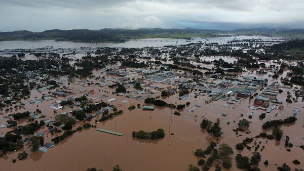
The City of Lismore under floodwaters in Feb 2022
The City of Lismore under floodwaters, February 2022.
Andrew King, The University of Melbourne; Linden Ashcroft, The University of Melbourne, and Sarah Perkins-Kirkpatrick, UNSW Sydney

The deluge dumped on southeast Queensland and northern New South Wales this week has been catastrophic. Floodwaters peaked at around 14.4 metres high in Lismore – two metres higher than the city’s previous record.

So how does this compare to Australia’s previous floods, such as in 2011? And can we expect more frequent floods at this scale under climate change? The answers to questions like these aren’t straightforward.

Climate change doesn’t tell the whole story, as extreme rainfall can occur for a variety of reasons. What’s more, it’s too soon to officially state whether this event is directly linked to climate change, as this would require a formal event attribution study. This can take months or years to produce.

In any case, we do know extreme events like this will occur more frequently in a warmer world. And the rising death toll, ongoing evacuations and destroyed homes make this one of the most extreme natural disasters in colonial Australian history.

Guest Post: Like rivers in the sky: the weather system bringing floods to Queensland will become more likely under climate change

Kimberley Reid, The University of Melbourne and Andrew King, The University of Melbourne

The severe floods in southeast Queensland this week have forced hundreds of residents to flee the town of Gympie and have cut off major roads, after intense rain battered the state for several days. The rain is expected to continue today, and travel south into New South Wales.

We research a weather system called “atmospheric rivers”, which is causing this inundation. Indeed, atmospheric rivers triggered many of the world’s floods in 2021, including the devastating floods across eastern Australia in March which killed two people and saw 24,000 evacuate.

Our recently published research was the first to quantify the impacts these weather systems have in Australia, and another study we published in November looked closely at the floods in March last year

We found while atmospheric rivers bring much-needed rainfall to the agriculturally significant Murray-Darling Basin, their potential to bring devastating floods will become more likely in a warmer world under climate change.

Wednesday, November 7, 2018

Storms and flooding for Melbourne Cup day, but media dares not mention climate change


Melbourne Cup day dawned with rain falling. Storms escalated with torrential rain through the morning. Power outages, train disruptions, flashflooding of stations and many low lying roads across the city eventuated. But the mainstream media failed to add 2 + 2 with the influence of climate change in this extreme weather event.

The previous day racing officials had ordered more racetrack irrigation overnight to reduce the firmness of the track. Perhaps they should have checked the weather forecast.

Intense rain events are becoming more frequent, the science is clear not only from models but also observational data. Part of the reason for this is a Warmer atmosphere that can carry more moisture. For every 1 degrees Celsius of warming the extra atmospheric carrying capacity is increased by an extra 6-7 per cent. So heavier rain. That means more flash flooding.

Thursday, October 10, 2013

Colorado extreme rainfall and flood event of 2013


Like many people around the world I watched and followed the astonishing rainfall and flood events in Colorado in September this year that resulted in at least 10 deaths, damaged some 18,000 homes, caused the evacuation of more than 10,000 people, washing away roads and bridges and isolating communities for a time. The rain and flood event is estimated to have caused $2 billion worth of damage.

The extent of the rainfall was unprecedented in meteorological records that stretch back a little more than 100 years. The extreme rainfall event has been described as a 1 in 1,000 year event. An Extremely rare combination of weather factors combining to produce the event.

Climate change however stacks the dice in several ways in increasing the probability of this event occurring in the future. A primary contribution is the increase in atmospheric capacity to carry water vapour which scientists have worked out to be 6 per cent to 7.5 per cent for each degree Celsius in average global warming. By the end of this century with average global surface temperatures projected to increase by 4 to 5 degrees with current business as usual scenarios, the atmospheric carrying capacity may be an extra 30 per cent, making extreme precipitation events like the Colorado event much more likely to occur.

Wednesday, June 26, 2013

Alberta Floods highlight a more active water cycle with climate change

An intense rainfall and storm event on June 20-21 has caused widespread flooding in the Canadian province of Alberta, encompassing much of the southern portion of the province including Canada's fourth largest city of Calgary. It is the worst flooding event in Alberta's recorded history, highlighting the more active hydrological cycle with climate change.

Over 120,000 people across the region were evacuated, 75,000 in Calgary (7% of the population), many now returning to flood damaged homes and businesses to start the clean up.

I am not going to say climate change caused the flooding. Clearly natural weather variability still plays a significant part in extreme weather events. But the reality is we have warmed the atmosphere and changed the base climate from which all extreme weather events are generated from. We are now living with weather in a more active hydrological cycle resulting in more frequent and intense storm events with a capacity to cause greater flooding.

Monday, January 28, 2013

Queensland 2013 bigwet floods, tornados and climate change

Ex-tropical cyclone Oswald has left a trail of damage and destruction from it's origins in the Gulf of Carpentaria to crossing Cape York and working it's way down the Queensland Coast. The storms brought destructive winds, tornados, rough seas, storm surge and torrential rain, followed by flooding. Quite a few rain records were broken for 24 and 48 hour periods in Rockhampton, Gladstone and Bundaberg with some rain gauges recording well over one metre of rain in 48 hours. Now flood level records are being broken for many river basins and towns like Bunderberg and Gympie.


Although the flood levels in Brisbane city may be lower than the devastating floods in 2011, largely due to better management of water storage in the Wivenhoe Dam, in many regional towns and areas these floods are much much worse and are at record levels.

While the Brisbane CBD may be spared flooding damage, many low lying suburbs around Brisbane will feel the force of the muddy dirty water swirling through their yards and houses. And regional towns are faring much worse in these floods than in 2011.

Thousands of people are being displaced, and hundreds are requiring rooftop emergency rescues from rapidly rising floodwaters especially around Bundaberg. Thousands will utilise emergency disaster assistance provided by State and Federal governments.

Asking whether climate change 'caused' these storms and floods is the wrong question. As climatologist Kevin Trenbeth outlines below, all weather events now have a component of climate change in them. It is now a part of our weather system contributing to all extreme weather events.

Wednesday, December 26, 2012

Increase in cyclone frequency in Indonesia blamed on climate change

Cyclone frequency in Indonesia in 2012 is 28 times that for the year 2002, according to the Indonesian Disaster Management Agency BNPB, with the increase attributed to the persistent impact of systemic climate change.

Indonesia straddles the equator on the edge of two important cyclone generating basins: the West Pacific basin, which can affect the eastern part of the country, and Indian Ocean basin, which affects the western and southern regions of Indonesia.

Sutopo Purwo Yuwono, spokesperson with the Indonesian disaster management agency (Badan Nasional Penanggulangan Bencana) BNPB told the Xinhua newsagency, "Global warming has resulted in the formation of more cumulonimbus clouds that could incite cyclones,"

Sutopo went on to predict that more cyclones would hit in Indonesia in March to April next year. Floods and landslides are expected to strike from January to March.

Friday, November 2, 2012

Crops devastated, food crisis looms in Haiti from Hurricane Sandy


At least 54 people were killed by Hurricane Sandy in Haiti due to the torrential rains, flooding and destruction of essential bridges and roads. Many Concrete homes and tent camps in Port-au-Prince setup after the 2010 earthquake are largely destroyed leaving up to 18,000 families homeless according to Haitian authorities.

Substantial crop loss occurred due to the Hurricane winds and flooding, threatening hunger and famine in coming weeks and months. Staple crops such as bananas and breadfruit were severely damaged by hurricane Sandy. "We'll have famine in the coming days," Kechner Toussaint, the Abricots mayor, reportedly said. "It's an agricultural disaster."

Related: Superstorm Sandy a wakeup call on climate change for the USA? | UN Reliefweb: UN relief agency estimates 1.8 million Haitians have been affected by Hurricane Sandy

Superstorm Sandy a wakeup call on climate change for the USA?

Hurricane Sandy on October 29. Courtesy: NASA


In the three presidential debates between Mitt Romney and Barak Obama climate change was never mentioned, despite it being raised in all previous campaigns going back to 1988. And then came Hurricane Sandy from the Caribbean. A late season category 1 tropical cyclone that combined with a north-easter from the Arctic to pummel the northern eastern coast of the United States, one of the most populous and industrialised areas on earth.

The Hurricane crossed the coast in New Jersey on Monday night, 29 October, at about 8pm not far from Atlantic City. The storm surge caused widespread areas flooded leaving coastal towns decimated. The winds of the hurricane caused trees to fall and whipped up a massive 3 to 4 metre storm surge. A full moon and a spring tide also exacerbated the storm surge. 10 metre waves were measured just outside New York Harbour entrance. (See Accuweather Superstorm Sandy Stats)

Related: Skeptical Science - Hurricane Sandy and the Climate Connection | Crops devastated, food crisis looms in Haiti from Hurricane Sandy | Inside Climate News: 3-D Maps Pictured Sandy's Devastation–Five Years Ago

Saturday, February 4, 2012

Climate change predicted to escalate Tropical Cyclone damage costs for US and China

A new study looking at the economic costs of tropical cyclone damage taking into account climate change, forecasts that tropical cyclones will cause $109 billion in damages by 2100. Increased vulnerability of populations and growing economic wealth is expected to double the costs from $26 billion per year to $56 billion by 2100. Climate change is predicted to add some $53 Billion in damages. Two countries are responsible for incurring 75% of the extra damage from climate change associated with tropical cyclones: the United States and China. But tropical island nations will incurr the highest damage per GDP - up to 37%.

The study - The impact of climate change on global tropical cyclone damage - is by Robert Mendelsohn, Kerry Emanuel, Shun Chonabayashi & Laura Bakkensen from Yale and MIT and was published in Nature Climate Change on January 15, 2012.

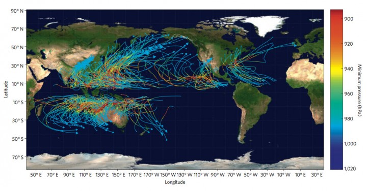
Caption: Storm tracks and minimum pressure for a sample of synthetic storms. The tracks show that storms are more frequent in the western Pacific. The minimum pressure (hpa) or storm intensity is measured by their color. Storm intensity is higher over the warm waters near the Equator and lower over the cooler waters towards the poles.

Extreme weather: Heavy rain and flooding in Fiji tests climate disaster preparedness


Fiji is experiencing heavy rain and major flooding with a 15-day state of emergency being declared in Fiji’s west coast areas. At least 8 people have died so far in the Fiji January-February 2012 floods with up to 51 reported cases of water-related diseases, thousands in evacuation centres and $30million in damages reported so far.

The Government’s Provincial Development and Multi Ethnic Affairs Ministry Permanent Secretary, Colonel Inia Seruiratu, declared the emergency on January 25 to apply to Ba, Lautoka, Nadi, Nadroga, Ra, and Tavua.

A 2009 publication produced by UNISDR and the UN Development Programme (UNDP) warned that in western Fiji, high-intensity floods would become more frequent. In the Nadi area, for example, these type of floods used to occur every 190 years, but with the influence of climate change by 2100 it is projected that they will occur every 25 years. (Institutional and policy analysis of disaster risk reduction and climate change adaptation in Pacific Island Countries: final report (PDF))